
The Iron Age
Let's move on to the Iron Age, about 500-600 BC, the time of the ancient Greek civilization. Here there is definite evidence of a village and a hillfort. I won't say much now, except to show this picture, because I'll cover this period more fully when we get on to the section on the Castle.
 Forward
in time again to the Roman occupation of about 2000 years ago, and the direct
evidence lapses again. However, we know that the Romans were in the area
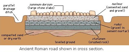
because they built one of their marvellous roads from Lichfield to Derby
- the Ryknild Way, now the A38. If you look on a map you can see how straight
they built them. The kinks and bends are mostly modern deviations from the
original route.
Forward
in time again to the Roman occupation of about 2000 years ago, and the direct
evidence lapses again. However, we know that the Romans were in the area
because they built one of their marvellous roads from Lichfield to Derby
- the Ryknild Way, now the A38. If you look on a map you can see how straight
they built them. The kinks and bends are mostly modern deviations from the
original route.
When the Romans wanted to go from A to B they went straight from A to B, none of this wiggling about nonsense. They were usually moving legions of soldiers and wanted to get there as quickly as possible. If you lay a ruler on the map you can see how straight it was.
The local section started at Lichfield (they called it Leocetum) proceeded past Alrewas and Barton and passed along what is now Wellington Street and Waterloo Street in Burton, past the Derby Turn, along Derby Road, through Stretton , crossed the Dove at the Monk's Bridge and straight on to Derby where they had a fort.
(Stretton means the -ton (settlement) on the Street (Roman road) )
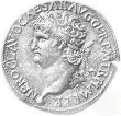 Roman
coins and other items have been found all along this route and they must
have visited the places a few miles either side of the road. Indeed they
often used native slave labour to do the manual labour so they might easily
have taken a few Tutbury residents for that purpose.
Roman
coins and other items have been found all along this route and they must
have visited the places a few miles either side of the road. Indeed they
often used native slave labour to do the manual labour so they might easily
have taken a few Tutbury residents for that purpose.
Incidentally there were some remains of the Roman road on the SW side of Burton, towards Branston, until about 150 years ago when the railway was built. They dug up the Roman bricks to use as hardcore to lay the railway track on!